I’m surprised that the state’s release of a Memorandum of Understanding with the new developers, suggesting open-ended subsidies and extended deadlines, has generated virtually no response beyond my coverage.1 It deserves more attention.
This article covers less ground, but it’s still important to know if developers Cirrus Workforce Housing and LCOR are being straight with us—and whether state officials are looking carefully.
For more than seven months, a new plan for Atlantic Yards publicly percolated with an implied trade-off: taller buildings would deliver more open space.
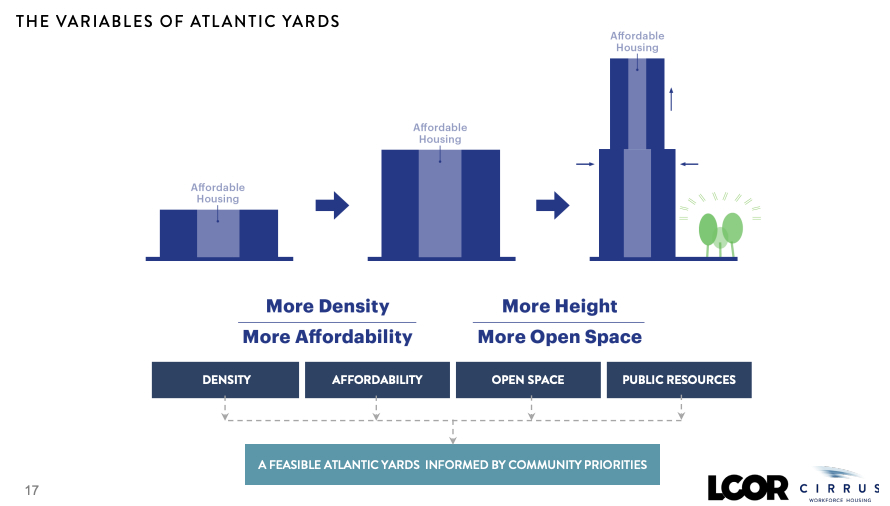
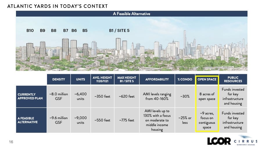
Indeed, one element in their “feasible alternative,” first described at a Nov. 18 public meeting, was that, by building taller towers with narrower footprints and also eliminating a building, Cirrus and LCOR would deliver an extra acre, or a 12.5% increase, of open space, for a total of about 9 acres.
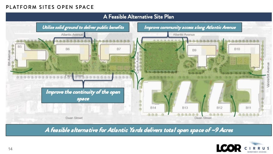
The tower planned for the B8 parcel, the portion over the Metropolitan Transportation Authority’s Vanderbilt Yard just east of Carlton Avenue, would be cut.
Public presentation
As Anthony Tortora, LCOR’s Co-Chief Investment Officer and Principal, put it during his presentation (below) on Nov. 18, 2025, “B8 is probably the most complex of the six platform sites, due to the convergence of the storage tracks and critical MTA infrastructure that are located at the western edge of the site.”
“In fact, B8 is so complex,” he said, “our idea is to eliminate a building on B8 altogether, reallocate that density elsewhere and deliver B8 as a park amenity.”
“Given B8’s location at the more or less center of the platform blocks,” Tortora said, “we believe this could be a transformative amenity that will provide over an acre of green space with ample connectivity to the neighboring sites.”
Crucial clarity (+ my error)
In reality, as I explain below, the B8 parcel already offered nearly an acre of open space. It couldn’t add an acre.
Rather, thanks to the subtraction of a building occupying little more than half an acre, that could augment the already planned green space to exceed an acre.
I erroneously summarized that as “promising better open space—notably an additional acre separate from any buildings, at the former site known as B8.”2
At the Dec. 8 workshop on open space, retail, and the public realm, Tortora repeated essentially the same explanation. (I wrongly described it as a “potential additional 1+ acre of green space, planned just east of Carlton Avenue.”)
That careful phrasing deserved more analysis at the time. Hence my second look.
Separately, the redesign of other buildings was, at least at the time, intended to add more green space, totaling an additional acre.
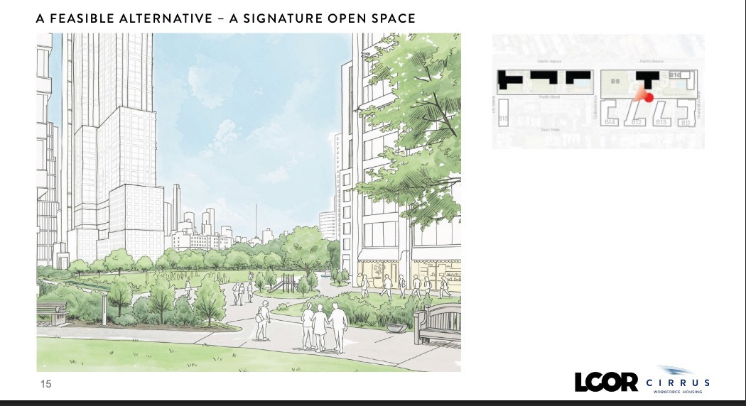
The image above makes it look nice. But it’s not enough information to truly judge. Numbers would’ve helped.
Public endorsement?
That proposed trade-off apparently won over a good number of attendees.
The Final Community Engagement Report, released April 30 by Empire State Development, the state authority that oversees/shepherds the project, concluded that, among workshop attendees, a majority (58%) preferred taller buildings if it meant “an expanded central open space.”
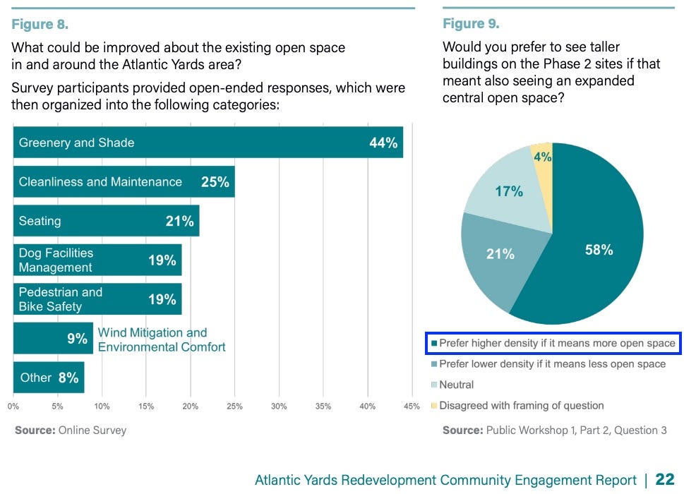
By contrast, 21% “prefer lower density if it means less open space.” That’s a little misleading, since “less open space” refers to the 8 acres already promised, which was less than what the developers proposed.
Note that 17% of respondents were neutral, while 4% disagreed with the framing of the question.
They may not have realized it, but they were onto something: the need to specify the dimensions of the open space, to understand whether the trade-offs were commensurate.
My coverage, as linked below, didn’t highlight the open space.

However, it did excerpt this Q&A:
Is the proposed open space really large enough to compensate for the thousands of new residents? There are concerns about the density.
Area needs that will arise with the addition of new residents will be studied as part of the environmental review process. The findings resulting from this review will inform the open space, infrastructure, and services needed to ensure the needs of current and future residents are met.
Of course, it would be impossible to significantly add open space to compensate. Expect the coming environmental review, as with previous iterations, to claim that the relative proximity of Prospect Park and Fort Greene Park—not actually so close!—makes up for it.
Drilling down
During a June 29 meeting of the advisory Atlantic Yards Community Development Corporation, where they shared the slide below, the developers finally disclosed that the increase in open space would be only half an acre, or 6.25%.
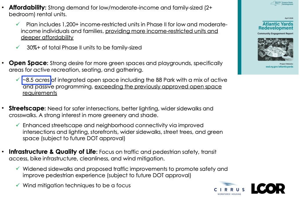
“I noticed that 9 acres of open space is 8.5 acres now,” asked Director Gib Veconi, also a key leader of the BrooklynSpeaks initiative to monitor and improve the project. “What happened to the other half-acre of open space?”
“I would say two things,” responded Cirrus Managing Partner Joseph McDonnell. “We said 9 acres—I think it included the arena site, so we pulled that out.”
That makes no sense. The arena site, including the plaza, was never identified as public open space for the project. (It’s not part of Exhibit M, below, which catalogs each site’s contribution to the open space.) Cirrus and LCOR had never previously suggested the arena site contributed to the 9 acres.
“The second thing, and this has a bunch of different reasoning behind it, we would actually like the podiums for these buildings to be articulated and brought out a little bit,” McDonnell continued. “We think that will actually help kind of create what I would call more of the Brooklyn scale, like we were talking about on Site Five, at the podium level.”
It also would help mitigate wind impacts, he added. “You don’t really want sheer buildings here. That covers a little bit more of the acreage.”
“Okay,” said Veconi. “So, you’re increasing the footprint a little bit to account for more of a podium.”
Another way to put it: the amount of open space gained is pretty much limited to eliminating B8.
Comparing the plans
What, though, does “previously” mean?
As indicated on the slide below, the buildings’ footprints seem smaller than those in the initial plan. That said, it’s possible that the space between the buildings allowed for more open space. We haven’t seen the dimensions.
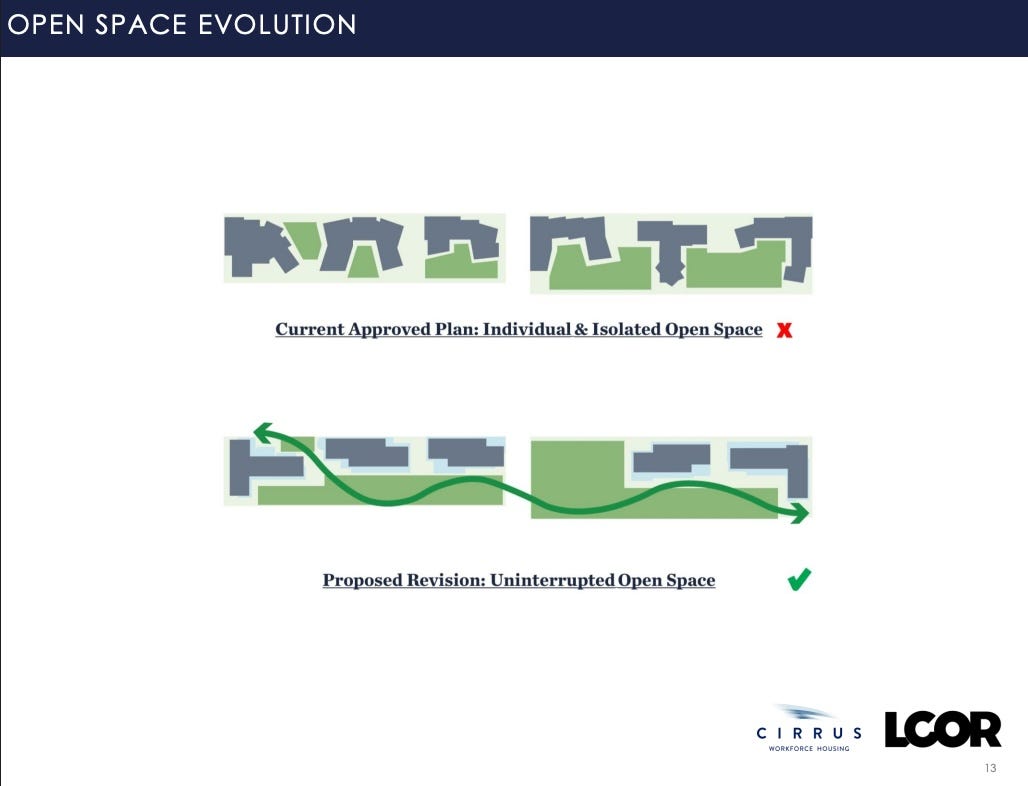
The slide below shows the redesign of the towers as of 2015. The footprints seem somewhat smaller than the 2006 design. That redesign was still expected to deliver 8 acres of open space.
The latest redesign creates more uninterrupted open space. The B9 tower, at least, appears to have a smaller footprint, while the others may not. We don’t know the dimensions.
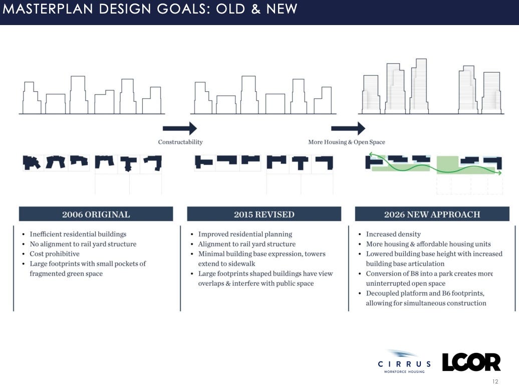
It’s unclear if the 2026 designs shown above incorporate the planned expansion of the podiums. Again, it would be helpful to have specifics.
Another look at the numbers
Though Cirrus and LCOR didn’t say so explicitly, I and some others mistakenly interpreted their rhetoric as suggesting that, by eliminating B8, they’d add an acre of open space.
That, however, would’ve required the building's footprint to occupy an acre. And that deserved a closer look.
In the project’s 2006 Design Guidelines, excerpted below, the total parcel area devoted to B8 was to be 64,400 square feet, or 1.48 acres. But the maximum lot coverage—the building's footprint—would have been 25,760 square feet, or 0.59 acre.
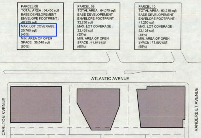
So that would have left at least 38,640 square feet of open space, or .89 acre.
Evolving plan
That plan seems to have evolved, however.
According to the 2021 version (below) of Exhibit M3 to the Development Agreement, the amount of open space allotted around the B8 tower site was 41,410 square feet (0.95 acre), slightly more than the 38,640-square-foot minimum.
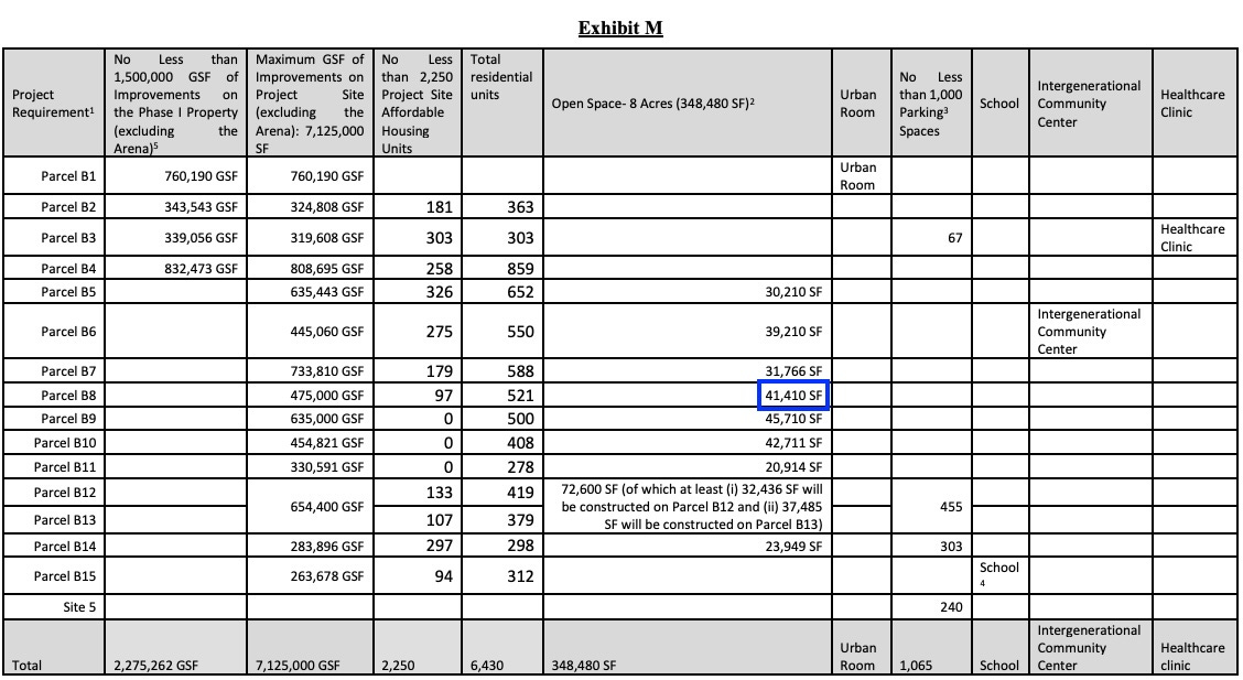
That implies slightly more open space. It would have left 22,990 square feet, or .53 acre, for the tower.
So it’s plausible that eliminating that smaller B8 footprint would yield about half an acre of open space. If so, the currently proposed total of 8.5 acres implies no net gain in open space from redesigning the tower footprints.
They may have been narrowed slightly, only to be increased. Have we seen an outline with the redesigned podiums?
Confirming evidence
According to the just-released Atlantic Yards Memorandum of Understanding (MOU), the B8 site would contribute 1.47 acres of open space, or 64,033 square feet. That’s nearly the 64,400 square feet cited in the Design Guidelines.
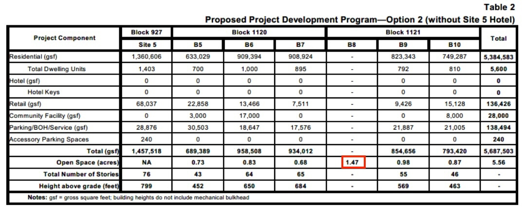
Earlier, that site was to contribute 41,410 square feet of open space. If we subtract that figure from 64,033 square feet, it suggests that the B8 footprint to be eliminated is 22,623 square feet. That translates to .52 acre. Again, that’s pretty much the promised increase in open space.
The bottom line
As BrooklynSpeaks asked in a July 13 posting before ESD’s planned Town Hall meeting:
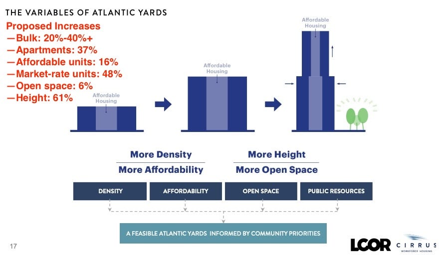
Does ESD believe participants in the community engagement sessions understood the development team was proposing increasing open space by 6% in exchange for a 61% increase in building height?
This provoked no response nor explanation. Nor were we told why they took so long to disclose the half-acre increase.4
It all raises a related question: If workshop participants had been given specific numbers estimating increases in building height and open space, would 58% have endorsed the trade-off?
See the annotated slide below.5
The bigger picture
As I wrote last November, when the plan was for 9 acres of open space, additional open space, however better designed, wouldn’t necessarily supply sufficient open space.
First, the ratio of open space per capita would remain well below the city’s goal or even median.
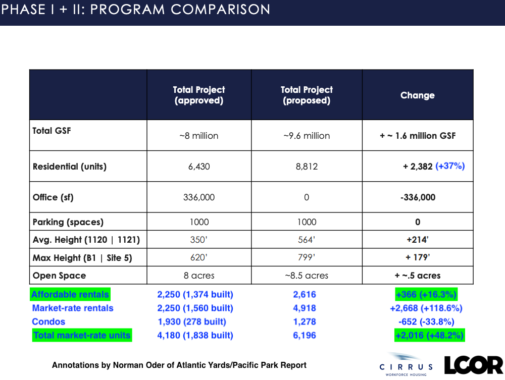
Second, the proposed increase in apartments, now 37%, would outpace the 6.25% increase in open space. That means the “open space ratio”—a standard metric to assess sufficiency—would go down, not up, even if that were mitigated somewhat by better design.

So the name “Pacific Park”—it’s unclear if the new developers would keep it—might remain something of a misnomer.
The other article so far, in The Real Deal, was rather tepid.
There was so much to cover that, with nothing released beforehand to analyze, I focused on other issues and didn’t drill down into documents specifying the scope of the B8 footprint and the expected open space.
This is an updated version of the Exhibit M document, about which I previously wrote in January 2020. It more precisely describes the amount of affordable housing at the B12/B13 sites.
In my coverage, I wrote, “Given that a quick look at the image above suggests a more significant increase, might the previous developers have fudged the math when promising 8 acres total?” Now I think that was unwise.
The source for the height comparison is here. Housing statistics are here, and in the slide below. Also see comparison chart from BrooklynSpeaks. While the project’s overall bulk would increase 20%, from 8 million square feet to 9.6 million square feet, the remaining project’s bulk would increase by more than 40%.