
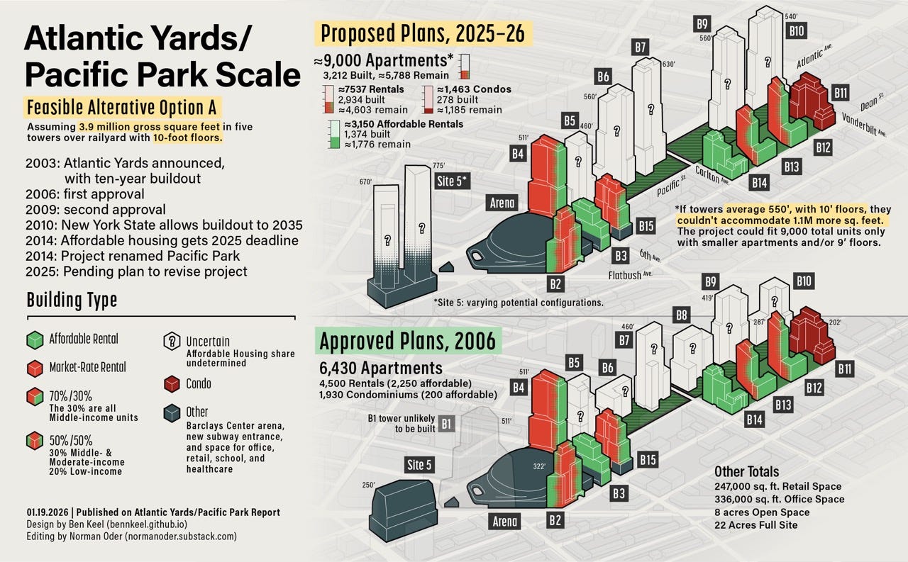
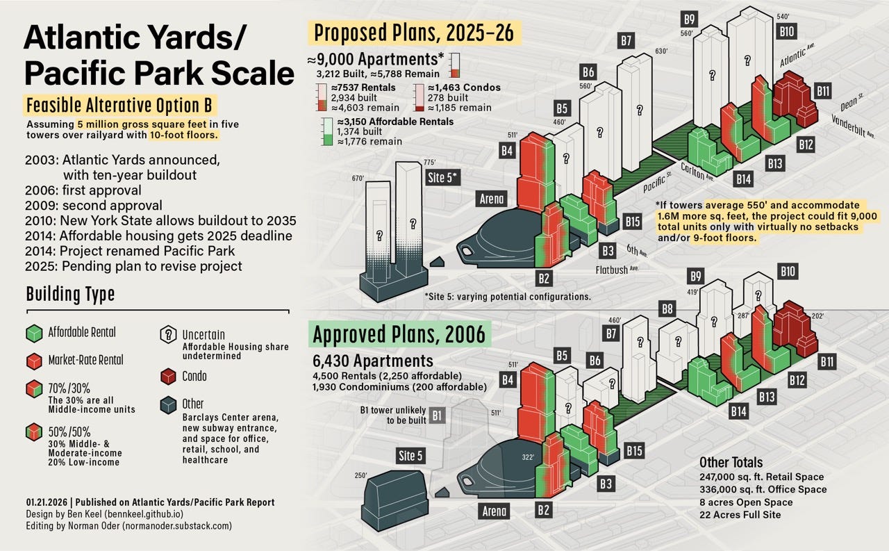
How Dense Would Atlantic Yards Be? Very Dense.
At a proposed 9,000 units and 19,000-plus residents over 22 acres, would the project have any peers? Advocate last month: "It does not feel like community. It feels like towers."

Yesterday, I expressed doubts the project developers, Cirrus Workforce Housing and LCOR, could fit 1.6 million more square feet—and a total of more than 2.1 million square feet—into five towers over the Vanderbilt Yard averaging 550 feet, or about 55 stories. Not with setbacks and 10-foot floors.
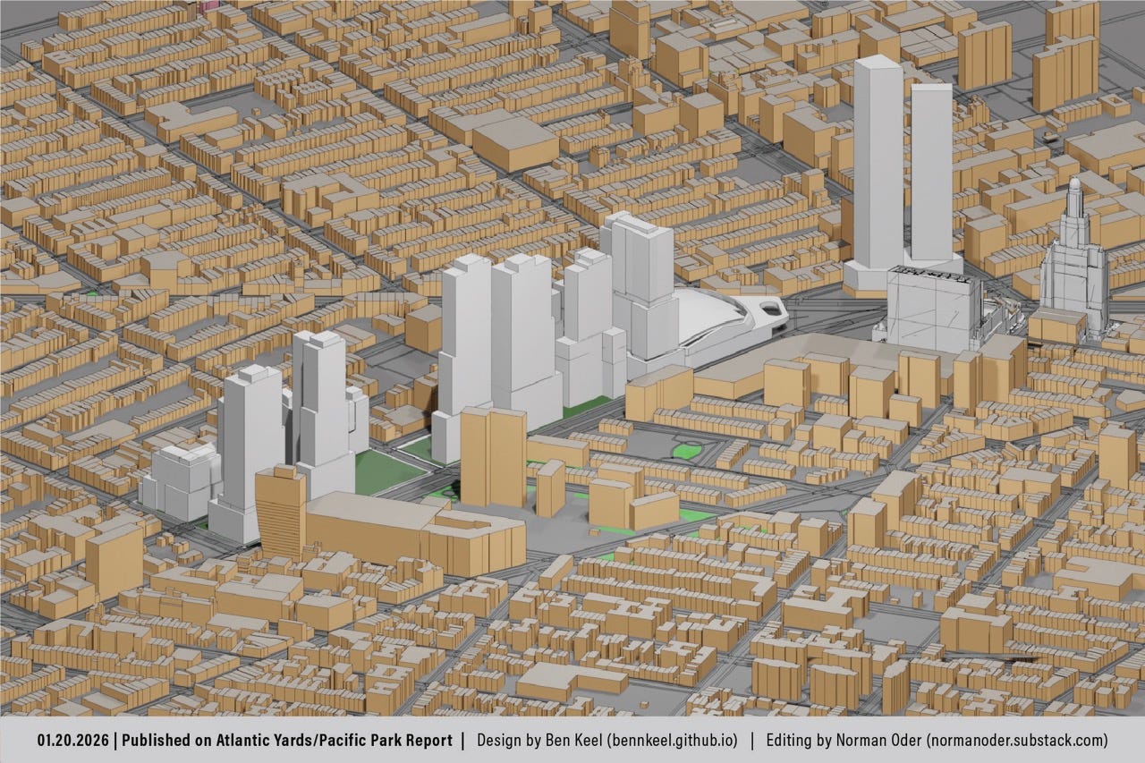
The numbers don’t comport with the clues we’ve been given, so renderings by my collaborator Ben Keel suggested the developers have downplayed the scale.
I’ve also asked state officials and the developers: What other large real estate projects in New York City have a density comparable to what’s proposed, an estimated 409 apartments and 875 people per acre? (Let’s see if we learn more, at tonight’s workshop.)
A pending question
A brief and relatively low-key exchange at the Dec. 2 meeting of the advisory Atlantic Yards Community Development Corporation (AY CDC) suggested the start of some crucial illumination of the developer’s emerging, ambitious plans.
AY CDC Director Ron Shiffman, veteran advocacy planner and academic, objected to participants using the term “density” as a synonym for bulk.
“You’re showing us the bulk,” he said, as indicated in the video below. “You’re not showing us the density. Density is the amount of bulk per square foot [of ground space]… It would really be interesting to see a density indicator, because then we would know how much we’re really building on this site.”
Managing Partner Joseph McDonnell of Cirrus said yes, they could provide the proposed FAR, or Floor Area Ratio, a common measure of density. They haven’t done so yet. (As I explain below, it’s a large number.)
Floor Area Ratio portrays the building’s bulk as a multiple of the underlying lot. An FAR of 2, for example, could mean two floors with full lot coverage or, alternatively, four floors covering half the lot. FAR can apply to individual buildings, as well as the total project site.
Past calculations
Isn’t this the job of ESD? The state’s consultants had, before project approval in 2006, calculated the Floor Area Ratio of the project as approved. The Final Environmental Impact Statement stated:
The project’s overall density would be more concentrated on the western end of the project site (the arena block and Site 5), where the overall density would equate to a floor area ratio (FAR) of 8.6 (10.3 FAR not including the area of the streetbeds incorporated into the project site); the FAR on the project site east of 6th Avenue and would be 7.4 (8.2 without the streetbeds incorporated into the project site). The total FAR of the proposed project would be 7.8 (9.0 without the streetbeds incorporated into the project site).
As the parentheticals suggest, the lower calculations are misleading, since, as architect Jonathan Cohn wrote on his Brooklyn Views blog in January 2006, “In Brooklyn, the FAR measures density relative to the existing pattern of streets and blocks.”1
Demapping streets both adds to the available land and downplays FAR. Downtown Brooklyn residential parcels, in 2004, were rezoned to an FAR of 10, which could be expanded to 12, if incorporating a plaza bonus or below-market housing.
Then again, beyond a small 1.15-acre park, the Downtown Brooklyn rezoning area, more than 12 times the size of Atlantic Yards, didn’t get significant new open space.
What’s the new Floor Area Ratio?
With a 9.6 million square feet over 22 acres (958,320 square feet, at 43,560 square feet/acre), Atlantic Yards would have an overall Floor Area Ratio of just over 10, not 7.8. (Without the streetbeds, the FAR, I estimate, might be 11.5.)
Let’s try an alternate assessment, using the state’s document—slightly out of date—citing maximum square footages per building.
I estimate the FAR for the three towers on the arena block—just relating to their own parcels, not the overall block—at 21.2.2
If we omitted the arena, the residential project is about 16.2 acres.3 To calculate the FAR, we’d first subtract the arena’s 670,000 square feet of bulk from the proposed 9.6 million square feet total. That would leave the non-arena bulk at about 8,930,000 square feet.
Some 8,930,000 square feet of bulk over 705,994 square feet (16.2 acres) suggests an FAR of nearly 12.65. Exclude demapped Pacific Street at the site’s east end and the number would be higher.4
What about Site 5?
The lot at Site 5, the parcel catercorner to the arena currently home to P.C. Richard and the former’s Modell’s, now the temporary Brooklyn Basketball Training Center, is 48,655 square feet. With an approved—at least tentatively—1,242,000 square feet in a two-tower project, the FAR would exceed 25.5.
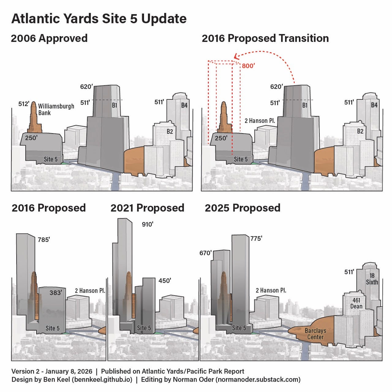
That’s more than twice the bulk of the Downtown Brooklyn rezoning and more than 50% greater than that approved for the nearby spot rezoning that created 80 Flatbush, aka The Alloy Block, of 15.75.
The Alloy Block, with two towers, is roughly comparable to Site 5 in shape and in location, bordering both Downtown Brooklyn and a row-house block. That said, it includes two schools, which both lower the overall FAR and helped justify the city’s willingness to grant additional bulk.
Apartments and population per acre
With 9,000 apartments over 22 acres, that yields 409 apartments/acre. At At 2.14 people per apartment, an estimate used in previous project documents, that could mean a total Atlantic Yards population of 19,260 people, or 875.45 people per acre. 5
(That estimate may be overblown, because the project has been built with fewer family-sized apartments than promised.)
That’s far greater than most large-scale projects in New York—more than double Battery Park City—but a little less than the London Terrace development in Chelsea, which, notably, has small units.
There could be fewer people per apartment if the project remains skewed to smaller units. Or there could be more, if ESD listens to advocates, like Ismene Speliotis of the Mutual Housing Association of New York (MHANY), reminding them that family-sized units were promised.
Accommodating the density
Had the original Atlantic Yards plan for 2 million square feet of office space been maintained, the full-time population would’ve been smaller. Most of that proposed office space was swapped for residential before the first approval.
At the Dec. 2 meeting, Shiffman asked about the number of people per acre: “That then will relate better to what the ratio of open space is to that development.” He didn’t get an answer, but I had already tried to answer it, in the below-linked article.
Cirrus/LCOR, taking a cue from predecessor Greenland, has proposed thinner, taller buildings, making it easier to build (on terra firma) and allowing for a larger amount of more contiguous open space.
By eliminating the B8 tower, they’d add an acre of open space. So the total open space would increase from 8 acres to more than 9 acres, perhaps 9.5 acres.
The 18.75% boost in total open space would be outpaced, however, by a 40% increase in population.
Official analysis: it doesn’t matter
In the past, state officials acknowledged open space deficits but said they don’t matter.
ESD’s June 2014 Final Supplemental Environmental Impact Statement acknowledged that the Department of City Planning seeks 2.5 acres of open space per 1,000 residents, including .5 acres of passive space and 2 acres of active space, while the citywide median ratio is 1.5 acres per 1,000 residents.
“Because these ratios may not be attainable for all areas of the city,” the document stated, ”they are considered benchmarks for comparison rather than policy or thresholds for determining impacts.”
So the projected .362 acres per 1,000 residents, in the ½-mile residential study area around Atlantic Yards, was not then considered a deficit.
That ratio likely has gotten worse. Since 2014, new buildings have been approved just east of the project, around Atlantic Avenue, adding to the population. They didn’t add incremental public open space.
Beyond that, as noted, the incremental open space added in Atlantic Yards/Pacific Park would be outpaced by the growth in population. Neither Prospect Park nor Fort Greene Park, despite ESD’s mention of them, are that close.
Speliotis on density and community
In her comment at the Dec. 2 AY CDC, Speliotis, who helped devise the Atlantic Yards affordable housing agreement between the advocacy group ACORN and developer Forest City Ratner (but not fulfilled), said she knew the project was “at the crossroads of Flatbush and Atlantic Avenue. I am not an advocate of three-story buildings on Atlantic Avenue.”
“When you say 950 feet, we are talking about a 95-story building. So let’s talk about it in ways that community residents can really understand what they’re looking at, okay? Because that is horrifying.”
The tallest tower proposed, at Site 5, would be 775 feet, or 77 stories, which is less than 95 stories but would be significantly larger than anything else built so far in the project.6 The implication is that, after a certain point, high-rise living is not conducive to families and community.
“That black tower downtown sticking out like Gotham revisited,” Speliotis said of the brooding Brooklyn Tower, the borough’s first supertall, “is just beyond the pale.”
“That corridor along the Flatbush [Avenue] Extension is just so dark and so unwelcoming and it is not a place inviting for building community,” she observed.
“It feels like towers”
“So you can build all the green space you want,” said Speliotis, “but if you’re surrounded by towers that are going to range between 55 stories and 95 stories, it does not feel like community to me. It feels like towers.”
The towers on the railyard would average 55 stories, but taller at Site 5.
“The other thing that’s really important is if we’re going to build communities, then we have to stop building studio and one-bedroom apartments,” Speliotis added. “You have an entire corridor along Flatbush [Avenue] Extension.”
“While everyone was fighting Atlantic Yards and Forest City Ratner 25 years ago, the city gave away Flatbush Extension. They just gave it away,” she said. “And what got built there was completely unaffordable. And again, I’m not defending Bruce [Ratner] or anything, but he was supposed to solve the crisis while we gave the city away along Flatbush Extension.”7
“But if we want to build community, you really need to start building some family-sized apartments,” she observed. Others have echoed that; the challenge is such units cost more.
A larger metric: per square mile
Let’s look at another density metric. A population of 19,260 people over 22 acres is 875.45 people per acre.
With 640 acres in a square mile, that’s 560,288 people per square mile, an extrapolation that, while unlikely, has been used as a benchmark in the past.
(Another caveat: Atlantic Yards is hardly a cohesive site. Notably, Flatbush Avenue separates Site 5, home to perhaps 800 to 1,100 apartments, from the arena block.)
That calculation is even more than what was assessed in 2006, when the New York Observer’s Matthew Schuerman reported:
The densest census tract in the country is located in West Harlem, where a 1,190-unit former Mitchell-Lama building stands surrounded by numerous tenements. The two-block area has, according to the 2000 Census, a density equivalent to 229,713 inhabitants per square mile.
Sounds positively suburban next to the density envisioned by Atlantic Yards in Brooklyn: between 436,363 and 523,636 inhabitants per square mile (based on estimated population of between 15,000 and 18,000 residents over 22 acres).
That’s more dense than the densest census tract I could find, as of 2010, a single Chicago building with 508,697 people per square mile.8
More and more density
That said, census tracts can be arbitrary, and sections of Downtown Brooklyn (and Long Island City) seem very dense, especially when sliced into smaller parcels.
Consider: 625 Fulton Street and 12 Rockwell Place, a two-building complex in Downtown Brooklyn not far from Flatbush Avenue Extension (and the towers Speliotis cited), contain a total of 1,150 apartments. Behind them is 80 DeKalb Avenue, with 365 units.
So that’s 1,515 apartments on Block 2094. With 2 people per apartment, the block would have 3,030 people.9
So 1,515 apartments and 3,030 people over 88,887 square feet (2.04 acres, see calculation in footnote above) leads to 742.65 units and 1,485 people per acre. That’s the equivalent of 950,400 people per square mile, well more than Atlantic Yards.
Moreover, next to it, 395 Flatbush Avenue Extension last May was announced for a giant tower with 1,263 apartments over a lot 49,153 square feet, or 1.13 acres. At 2 people per apartment, it could house 2,526 people.
That translate into about 1,135 apartments and 2,235 people per acre—the equivalent of 1,430,656 people per square mile.
Such buildings require, at minimum, vertical amenities. As to open space and public buildings like schools, that responsibility is shunted elsewhere.
In perspective
In 2006, Schuerman wrote in response to Shiffman’s commentary opposing the project, headlined Atlantic Yards: Staving Off a Scar for Decades. Shiffman had previously held his tongue “in part because I believed that the inclusionary housing component was an important victory” and he thought a better plan would emerge.
“While this area along the Atlantic Avenue corridor could accommodate higher densities, density is a relative term,” he wrote. “The density proposed by Forest City Ratner far exceeds the carrying capacity of the area’s physical, social, cultural, and educational infrastructure. The Atlantic Yards density is extreme and the heights of the proposed buildings totally unacceptable.”
Well, Atlantic Yards—or, at least, the sunken railyard claimed to be blighted to enable eminent domain—has indeed remained a scar for decades. (Well, less than one-third is part of the arena block.) There’s a greater appetite for height today, but the overall bulk has its limits.
The pending question
“If Forest City Ratner’s proposal proceeds at the current scale, it would constitute the densest residential community in the United States and, perhaps, Europe, with the exception of some of the suburbs of Paris,” Shiffman wrote.
Would it be the densest residential community? Well, that’s why I asked the question.10
Some smaller assemblages, as noted above, would be even denser. Whether they’d constitute a community is another question.
Shiffman has continued to raise the issue of carrying capacity, notably regarding plans for Site 5. That should be part of the broader project discussion.
Cohn called it a “a tricky strategy: rather than decrease the built space, the site can be ‘expanded’ by taking the area of the streets. By demapping the streets and counting them as open space, the project’s ratio of open to built space looks better - as a number.”
Here’s my math. The arena block, when the Barclays Center was to be constructed, was described in DOB documents as 325,360 square feet, or 7.47 acres.
The Barclays Center is 670,000 square feet of volume. The approved towers have a total of 2,655,007 square feet (B1: 1,106,009; B2: 380,687; B3: 343,682; B4: 824,629). B1 hasn’t been built.
Add the arena and the total is 3,325,007 square feet, or 7.47 acres, which includes two demapped streets. That leads to a Floor Area Ratio of a little over 10.2. (Subtract demapped Pacific Street and Fifth Avenue and the underlying lot would be smaller, elevating the FAR.)
Let’s subtract the footprints of the three existing towers on the arena block.
B2, 461 Dean Street, has a lot area of 11,362 SF and an FAR of 29.27, according to the DOB. But that’s misleading, since part of the tower looms over the arena. So let’s estimate the lot area at 18,362 SF, adding 7,000 square feet, and lowering the FAR.
B3, 38 Sixth Avenue, has a lot area of 22,766 SF and an FAR of 7.65, according to the DOB. B4, 18 Sixth Avenue, has a lot area of 31,906 SF and an FAR of 23.96, according to the DOB.
So the cumulative lot area for the three buildings (18,362+22,766+31,906) is 73,034 square feet. Their approved square footage (380,687+343,682+824,629=1,548,998 square feet) over 73,034 square feet results in an FAR of about 21.2.
Subtract the three towers’ 73,034 square feet lot size (see above footnote) from the arena block total, 325,360 square feet. That leaves 252,326 square feet, or 5.79 acres, for the arena, plaza, and transit entrance, part of which was once supposed to support the B1 tower.
If we subtracted that total-related 252,326 square feet from the project’s 958,320 square feet. That leaves 705,994 square feet, or a bit more than 16.2 acres.
Parts of Pacific Street and Fifth Avenue also were demapped for the arena.
Were the arena site excluded, the population per acre would be much higher.
Speliotis also said, “I disagree with the statement that the clock tower”—the Williamsburgh Savings Bank tower, aka One Hanson—”is 55 stories high. That is not true. It’s not 550 feet tall. (It’s 512 feet tall, but it has 37 stories or 34 stories, because of a significantly large entrance hall, now part of a retail condo, and a non-residential tower.)
Speliotis cited a March 16, 2006 ACORN report called Sweetheart Development: Gentrification and Resegregation in Downtown Brooklyn, which pointed to the lack of affordability in rezoned Downtown Brooklyn and suggested—overoptimistically, it turned out—that Atlantic Yards, a result of the state’s override of zoning, was an exception. That said, ACORN had focused on other rezonings rather than Downtown Brooklyn before approval.
Some better-equipped researchers may learn more.
Given that 625 Fulton has 342 studios, 492 one-bedrooms, and 264 two-bedrooms, the multiplier probably should be lower than the one for Atlantic Yards.
Here’s my math:
80 DeKalb: 335,187 square feet on a parcel 13,626 square feet
12 Rockwell: 51,444 square feet, on a parcel 16,469 square fee.
625 Fulton: 957,589 square feet on a parcel 58,792 square feet (or 764,167 zoning square feet for the two latter parcels)
Total bulk: 335,187+51,444+957,589=1,344,220 square feet of bulk. Total parcel square feet: 13,626+16,469+58,792=88,887 square feet. That suggests a Floor Area Ratio of 15.1.
Towers are expensive to build. The taller they are the more the cost per sq ft. That fights affordability and requires more subsidies.
Glass towers are triple-whammy unsustainable (energy required to manufacture the high-tech glass, energy used by a glass towers up in the winter winds and the summer sun, life-cycle cost of the high-tech glass which loses R-value over two to three decades).
A Short Discussion of Residential Building Heights in New York City: https://blog.massengale.com/2023/03/23/nycresheight/
The FAR calculations here are eye-opening! When you break down the desnity math from individual buildings to the full site, the real scale becomes undeniable. I've followed similar mega-developments and the denominator problem is always the same: adding open space sounds great until you realize population growth outpaces it by 2x. The comparison to London Terrace is particuarly telling because those small units create their own carrying capacity issues.